
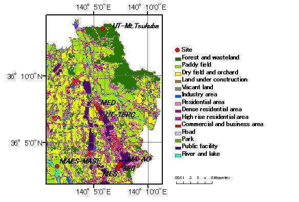
Geography of Tsukuba
Tsukuba Reference Site is situated on the Joso Plateau (20-30 m a.s.l.)
consisting northeastern parts of Kanto plain. Land cover of the site
is mainly consisted of two parts, one is the urbanized zone stretching
north-south directions used for public facilities, residential areas, and
commercial and business areas (so-called Tsukuba Science city), and the
other parts are rural areas used for paddy field, dry field and orchard.
In August, 2005, the Tsukuba Express Railway started its business, and
Tsukuba Science city is rapidly urbanizing. Two rivers are running
in the north-east and south-west of the site, named Sakura-gawa and Kokai-gawa,
and the paddy fields are mainly distributing along those rivers.
Mt. Tsukuba (876 m a.s.l.) locates about 7 km north of the city center,
mostly forested by beech, tall evergreen oak, and Japanese red pine tree.
In the calm winter days, development of nighttime inversion layer over
the Kanto plain causes thermal belt along the mountain slope, and it is
utilized for local habitat and fruits plantation.Therefore, CEOP-Tsukuba
reference site covers various of land-use with faster growing populated
city representing land cover in the Kanto plain, central Japan.
Soil type
According to Tosaki et al., (2008), soil type distribution in the area around the Tsukuba is explained as follows. “Underlying the surface soil are a loam layer (1.5-20. m; the Kanto Loam), a clay layer (2.5-9 m; the Joso clay), a sand layer (9-30 m), a fine sand layer (30-47.5 m), and a sand & gravel layer (47.3-55m) in descending order. Basement rocks in the area consist of granitic and metamorphic rocks, forming the Mt.Tsukuba. The water table is generally observed within the Kanto loam or the Joso clay.” Surface soil type is variable depending on the stations and land use. As for the constructions of new Tsukuba city, near-surface loam layer was disturbed by the sand layer.
Tosaki et al., 2008: An estimate of local
bomb-produced 36Cl fallout using the depth profile of groundwater in the Tsukuba upland,
central Japan. Hydrological Research Letters, 2, 9-13.
Published online in J-STAGE (www.jstage.jst.go.jp/browse/HRL). DOI:10.3178/HRL.2.9